An account of the many tornados reported in Kansas May 23, 2008.
PONCA CITY, Oklahoma — My friend and fellow news junkie, Chris Caldwell, spent May 23, 2008 chasing a Kansas tornado outbreak.
For those not in this neck of the woods, the western part of Kansas was lit up with tornado warnings most of the day and well into the early morning hours.
Caldwell, who used to chase storms for KOCO-TV in Oklahoma City, talked about what he saw.
"I left Ponca City around 2 p.m. and headed for Alva," said Caldwell.
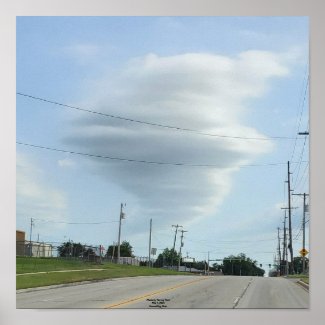
"As I arrived I made a call to the station and they pushed me on west to Buffalo. I had just arrived there when they called and had me push on over to Beaver County in the Oklahoma Panhandle. A storm was moving northeast and was reported having a rotating wall cloud. I could see the wall cloud from quite a ways out and as I got closer I started seeing two funnels dipping out of it and I noticed two separate areas with rotation and the storm cycled up and down and eventually pushed into Clark County in southwest, Kansas.
"I saw the first tornado this cell produced just north of Englewood, Kan. which is just across the Oklahoma border in Clark County. It was on the ground for less than a minute. The second tornado was northwest of Ashland, Kan., and it was down several times for a total of about eight minutes.
"The third tornado was several miles farther north of the first in Ashland that I saw. It was down for about two minutes and the fourth tornado was one mile west of Greensburg, Kan. and I'm unsure the total time it was on the ground since it was dark by this time and seeing it was very difficult between the lighting flashes."
Greensburg was destroyed by a large tornado in 2007 and many residents were still leaving in FEMA trailers when this outbreak hit.
"Greensburg, residents were watching the skies very close once again," he said. "I witnessed a tornado there just one mile west of town. No video or pictures since it was nighttime and I wasn't able to get it on tape between the lightning strikes. There were also reports of two other tornadoes near Greensburg.
"The first one was reported nine miles southwest of the town and the second report indicated a storm moving near the area that was producing a large wall cloud and producing occasional tornadoes. The National Weather Service will do a survey and its possible this was just one tornado being reported by two or more people.
Caldwell said he saw five semi trucks flipped over by the high winds. "The first one was flipped just as it passed by me as Rear Flank Down Draft winds occurred from the back side of the tornado that was north of Englewood, Kan.," said Caldwell.
"I pulled to the side of the road and recorded a 92 mph wind gust from that one. I was hit by more RFD winds from the first Ashland tornado and I recorded it at 126 mph. It rocked my vehicle and I felt the drivers side lift off the ground a couple inches for just a split second so I turned into the wind and road it out. The 126 mph wind only lasted for a second at most and then dropped to 89 mph and then down to 61 mph and held steady there for a good eight to 10 seconds.
"The road was blocked by the flipped semi so I had to go back to the north to go around and try to get back to Oklahoma and I came upon the next four semi's flipped over and they were all within a 200 yard stretch of the highway and it was blocked and rescue workers were already there at the scene getting one of the trapped drivers out.
"So basically I was trapped between the first flipped semi and the four flipped semi's. Officials allowed me to go around the mess and I continued north and came upon three oil tanks pushed 25 feet from their pad. There was also numerous power lines down and there was a very strong odor of both natural gas and oil.
"By this time it was getting dark and the only way back to Oklahoma without going down muddy roads and taking a chance of getting hit by the core of another storm coming out of Oklahoma, that had produced the Fort Supply tornado and was reported having baseball sized hail, was to continue north and then back east through Greensburg.
"That is when I caught back up with the cell that had produced the first three tornadoes I had seen and thats when I caught the tornado one mile west of Greensburg. So, all four tornadoes were produced by the same cell. From there I had to race back east to try and stay ahead of yet another tornado producing storm reported having a large wedge tornado and was also reported as having softball sized hail and coming from southwestern Kansas and I just almost got by without any problems but then came the hail and I was hit by quarter sized hail for about a half mile or so and then it was a clear path back to Wichita and back down Interstate 35."
Caldwell made it back to Ponca City about 1:30 a.m. Saturday.
"I was sure glad to get home but was not able to hit the sack just yet since I had to then edit all my video for the 5 a.m. newscast," he said.
"What a day and night."
The storm prediction website indicates 73 tornados were reported in Kansas from May 22-23.
Nationwide Totals are listed as 48 Tornados for Thursday, May 22rd in Colorado, Wyoming, Kansas, Nebraska, and California and 62 Tornadoes for Friday May 23rd in Colorado, Wyoming, Kansas, Nebraska, and Oklahoma.
"It is possible the tornado count over the past two days will be reduced or increased since its common for multiple reports from different people for the same tornado and some reports come in late and some aren't listed in a timely fashion," said Caldwell.
"The four tornadoes I personally saw only one of them appears on the SPC Web site even though I reported all four as they occurred."
No comments:
Post a Comment